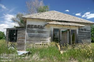
We started the day in WaKeeney KS with two primary target options along a warm front: the Colorado-Nebraska-Kansas border region, and northeast Kansas. The capping inversion was stronger in northeast Kansas, so storms were more uncertain. Plus after spending a lot of time chasing east this year, the call of the high plains was strong and we thought higher elevation may work for us as well, so we targeted the western option. So we drove to the Haigler NE area and waited. And waited. And shot photos of the Rebel Inn in Haigler. And waited. And drifted west toward Wray CO. And waited. Storms kept developing along the front range of the Rockies to our west, but they would weaken as they moved east onto the high plains. Not seeing much signs of life in the cloud field in the area, we were tempted a couple of times to head west farther into Colorado, but held on until we finally saw development a bit to our east - near Haigler (of course). So we started following it east.
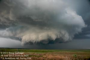
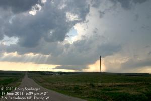
The storms continued to develop as we drove east through Haigler and we got in front of the storm north of Benkelman.


North of Benkelman, we came across a wall cloud with very strong rotation and rising motion. We have no idea how it did not produce a tornado with such strong low-level rotation with the rotating cloud elements just a few hundred feet above the ground.
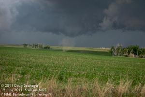
After this wall cloud dissipated, we drove east where the storm quickly did develop a tornado to our north (followed by the sounds of screams of kids in the backyard of a nearby house when they saw the tornado.) The tornado persisted for a couple of minutes before dissipating.


Soon after the tornado dissipated, we saw a rotating column of dust move from west to east across the fields a few hundred yards to our northwest and north, although we are not sure if this was a product of storm-scale rotation or a gustnado/dest devil-type feature.
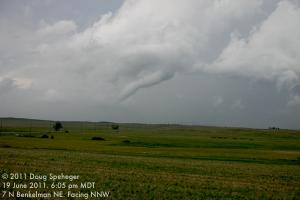
We followed the storm east, but then looked at radar and saw that the primary rotation was anchored to the west near the road that goes north out of Benkelman (and even farther west than tornado we had just seen.) So we drove back west and eventually saw another tornado west of where the original tornado had been. We don't know when the tornado developed, but we watched it dissipate at 6:06 pm MDT/7:06 pm CDT.
Meanwhile a small low-precipitation supercell had developed to our west, but it looked more disorganized as it moved east.
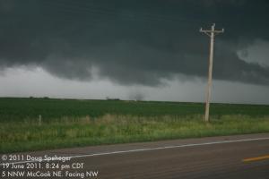
We followed the original storm east and watched it try to organize more significantly again north of Trenton, but it could not quite do it. Then we went east again, then north from McCook to find the updraft area of the storm again. As we drove north, we got a glimpse of what looked to be a well-developed tornado to our northwest partially hidden by trees along the side of US-83. Whatever we had seen was not as well-developed by the time we reached a clearing, although there still was a strongly rotating wall cloud and circulation at the ground below it lifting dust and debris which lasted another minute or two. Photos from other chasers and spotters did confirm that what we had seen a glimpse of was indeed a well- developed, albeit brief, tornado.
There were no convenient roads to follow it east, so back south to McCook and east toward Bartley and Cambridge. We drove south of Cambridge to find a place to watch, and although it still looked somewhat organized, it was getting darker, and more rain was developing near the updraft of the storm to make it more difficult to see what it was doing. So we let it pass us to the east and we then drove north behind it to near Harry Strunk Lake and took photos of the great storm structure and amazing lightning show that the storm was producing to our east. Other storms formed to our north and west that also gave good lightning displays.


The next bit of fun was what seemed like it would be an easy trip to a hotel in Lexington, except that we found that the state highway that we were going to use to stay in front of the western storm was unpaved. And it looked wet/muddy after the original storm moved over it, so that did not look like a good idea after all. So we ended up driving west to Curtis in front of the next storm (barely beating the big hail), then turned the corner and to northeast/east toward Lexington.
The last bit of fun was after we checked into the hotel in Lexington when the western storm finally caught up with us. My plan to get to sleep right away was interrupted by a lot of close lightning strikes, strong winds and small hail. A little before 2 AM, Dave texted me from his room "Is it just me or was the building shaking?" Winds gusted to 44 mph at the Lexington airport about 3 miles to our northwest, but Dave was estimating maybe 70 mph winds looking out his window. But we did get some rest before another big day on the 20th.