Spēg's 2008 Chase scorecard:
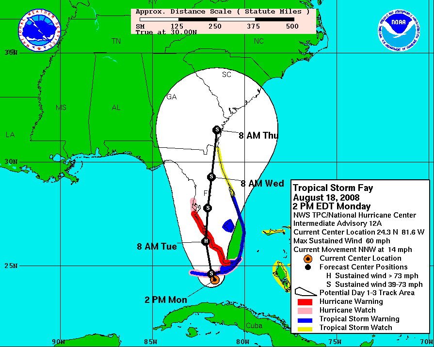
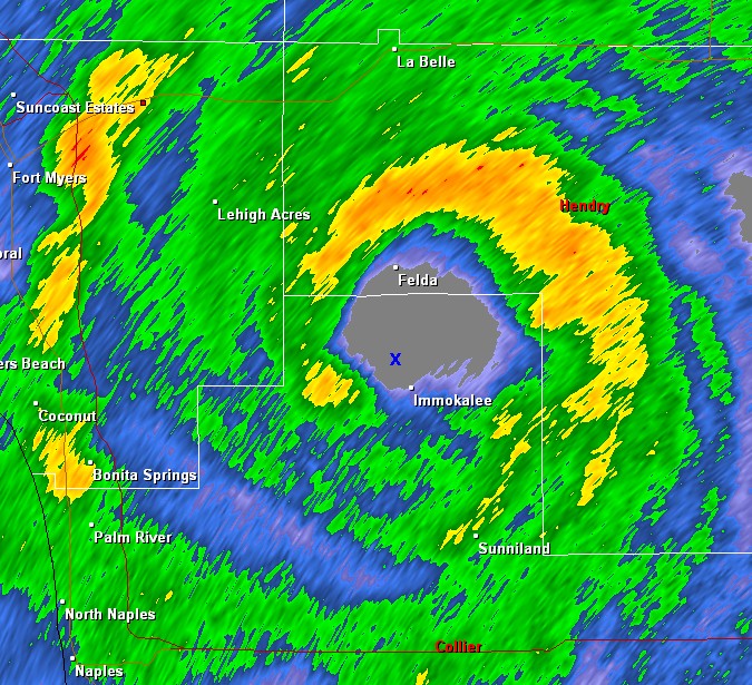
Tuesday, August 19 - IMMOKALEE FL (TROPICAL STORM FAY)
~80 miles. ~2:00. Tropical Storm Fay eye.
|
My first experience with a Tropical Storm (if you don't count Tropical Storm Erin in Oklahoma while at work August 19, 2007, which was an experience in itself). Tropical Storm Fay went across western Cuba, and then moved up toward southwest Florida, where I happened to be visiting my family. The National Hurricane Center forecast path and the consensus of the computer models looked like a high likelihood of it developing into a minimal hurricane, and then moving toward Fort Myers (where I was). So I was in my first Hurricane Warning. Late Monday night, Fay was already moving a little east of north giving the first signs that it would come onshore farther south. And it did come onshore near Cape Romano, FL at 5 AM EDT, about 55 miles south of Fort Myers. And since it came onshore sooner and farther south than it looked like it might have, it did not have time to intensify into a hurricane. When I got up for good Tuesday morning, Fay was already onshore. But I noticed that the radar presentation had actually improved compared to when Fay was over the Gulf. There was actually a well-developed eye (or at least eye-like feature) to the south, even though there had not been one when Fay was over the Gulf. With the eye so close, I figured that I had to go check it out. So I took my dad for a drive with me. I don't think I would have done this had this been any stronger than a minimal category 1, but with it rated as a tropical storm with maximum sustained winds of 60 mph, I figured that it would probably not be much worse than the winds we experienced driving through northwest Oklahoma on May 26 (see below) So we drove east from Fort Myers to La Belle, and then south on state highway 29. The center of Fay was crossing this highway, which would be the only chance to get into the center for a while since there are very few roads east of this highway in the swamplands. We drove through 5 to 10 miles of the heavy rain and strong winds associated with the "eyewall" before breaking into the eye very near Felda, FL. I estimate the winds were sustained up to 45 mph with some gusts of around 60 mph in the "eyewall." But when we broke into the eye, the low clouds eroded, the rain stopped except for a little bit of drizzle, and the winds became light. I actually do think my drive through northwest Oklahoma on May 26 was slightly worse and much more persistent than what we drove through. There was still lots of mid and high-level clouds in the eye, so it was not clear in the eye. But that didn't surprise me given the relatively weak storm and it having been inland for a few hours already.
Overall, an interesting little bonus during my family visit. Although the persistent rainbands over the next few days got old. Dave Ewoldt saved a few high-detail radar images from the Key West FL radar, including this one at 1332Z (9:32 am CDT) which shows an "x" where I was at the time. |

 We stopped just south of Felda (a the time of the radar image above), and took some photos,
including the one on the left. On the small scale, tropical storms just are not as photogenic as tornadoes. The edge of the
blacker clouds behind me show the edge of the eye where low clouds and heavy precipitation is just about a mile to the north.
The low clouds could be seen moving very fast from right to left. The "eye" was about 10 miles in diameter, but there was still
the sense of being surrounded. We continued driving south until we got into the edge of the heavy rain and strong winds at the
south edge of Immokalee, then we turned around and retraced our route out the north end of Fay. There was some large trees
broken in Immokalee indicated that they had some stronger winds than we experienced when the storm went through town.
We stopped just south of Felda (a the time of the radar image above), and took some photos,
including the one on the left. On the small scale, tropical storms just are not as photogenic as tornadoes. The edge of the
blacker clouds behind me show the edge of the eye where low clouds and heavy precipitation is just about a mile to the north.
The low clouds could be seen moving very fast from right to left. The "eye" was about 10 miles in diameter, but there was still
the sense of being surrounded. We continued driving south until we got into the edge of the heavy rain and strong winds at the
south edge of Immokalee, then we turned around and retraced our route out the north end of Fay. There was some large trees
broken in Immokalee indicated that they had some stronger winds than we experienced when the storm went through town.
Monday, May 26 - GREENSBURG KS
557 miles. 11:45. Pre-tornadic supercell.
| 
Chase vacation: Day #4 (and final day) in the field. We went into southwestern Kansas where there appeared to be sufficient wind shear for tornadoes. We watched a storm develop south of Coldwater KS and followed it northeast until it decreases enough to not be viable. A quick check of radar did not show anything else in the area too exciting, so we were thinking about dropping south into Oklahoma where some storms had developed, even though the shear was better in Kansas. As we were approaching Coldwater from the east, we noticed a storm to our northwest that seemed to be organized much more than the earlier radar had suggested. And Dave Ewoldt called me just before we reached Coldwater that the radar presentation was improving. So we changed our plan and followed that storm, then a storm that developed just to its south that also developed good structure. The storm moved into areas just southeast of Greensburg. Unfortunately, it began to turn to the right and refused to cross the highway between Greensburg and Pratt. And as was the case in northwest Kansas last week, there were no good road options to allow us to get onto the other side of the storm. So we waited in Haviland caught between two storm cores, between this storm and another storm that developed on its flank, and hoped that the storm to our east would cross the highway and let us east, but it did not. It produced three tornadoes to our southeast and east, but there was no way to get there without risking driving through some big hail. So we found the right area and the right storm, but road options would not let us see the tornadoes. The best structure was while driving, so alas, no photos. On the way back south, we did stop to take photos of a windmill with storms developing in the background (photo on left). However, the drive home ended up being more eventful. Across eastern Harper County and into Woodward, I started encountering very turbulent and gusty winds, probably thanks to some dissipating showers and storms in the area. After fueling up in Woodward, the winds got much worse driving from Woodward across southeastern Woodward County where we were being battered by very turbulent winds that Jennifer and I were estimating were gusting to 50 to 60 mph. It was quite a challenge to drive in these winds. They finally lessened as we approached Seiling. |
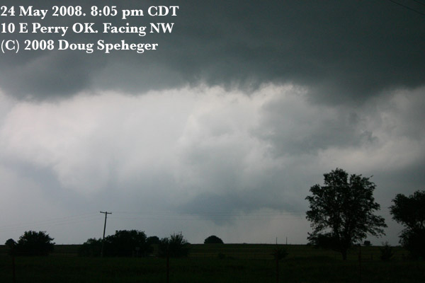
Saturday, May 24 - PERRY OK
465 miles, 9:30. Post-tornadic supercell.
| 
Chase Vacation: Day #3 in the field. Our initial thoughts the night before was that we would probably be chasing in southeastern Nebraska today. But storms overnight changed the plan. When we started looking at data, we saw an outflow boundary across northern Oklahoma that was left by the overnight storms. These storms also "worked over" the atmosphere in eastern Kansas and the low-level moisture looked much more marginal for southern Nebraska. So we were torn between targets of southeast Nebraska and southern Kansas and northern Oklahoma. Finally, the outflow boundary to the south and the greater instability in Oklahoma was too much to pass, and we went south to see if other storms could develop in southern Kansas. Elevated storms had developed on the outflow boundary in northern Oklahoma before we even left Hays. And the surface-based storms developed and the first tornado warning for the storm was when we were still in the Great Bend Kansas area. Our primary plan was never to play the big Oklahoma storm as we kept thinking that storms might form in southwest Kansas (and it's a long, long way from Hays KS to Hennessey OK). But driving south for "Plan A" allowed us to get closer to the slow-moving Oklahoma storm which we kept as a "Plan B" through our drive. When it was obvious nothing else was forming, we kept driving toward the big storm and were within 20 miles when tornadoes were reported near Orlando, and were within about 8 miles when a tornado was reported south of Perry. But were not in position yet, and knew we had to get around the lakes. So we finally got into position east of Perry, and we did see a nice clear slot develop (photo on right) and perhaps a wall cloud. But the storm was weakening. There was some impressive lightning activity, but it waned as I got my camera and tripod set up, and only one shot got some distant lightning. Then back to Norman. |
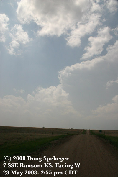
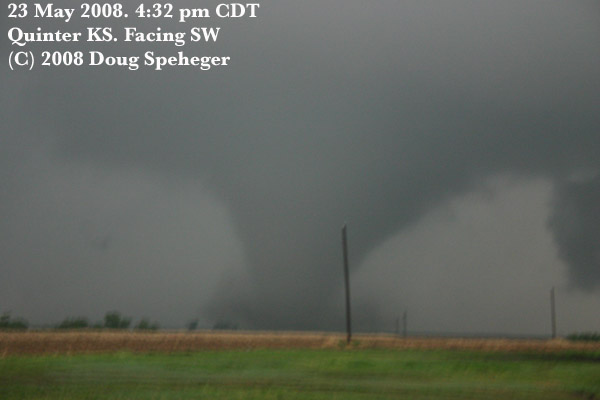
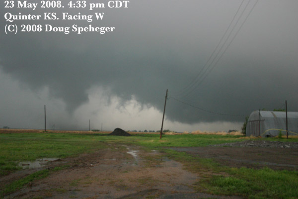
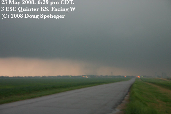
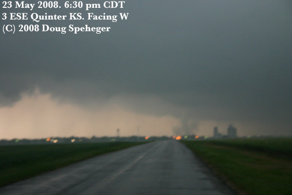
Friday, May 23 - QUINTER KS
293 miles, 8:45. Four to seven tornadoes. Two large.
| 
Chase Vacation: Day #2 in the field The dryline was forecast to lay across western Kansas again today, in roughly the same area. So the longitude was the easy part of the forecast, but the latitude was the question mark, although it ended up not really mattering where in Kansas along the dryline as tornadic storms were widespread. But we initially thought we would target the same area where we were yesterday, so we started driving from Hays to Dighton. Before we got to Dighton, cumulus clouds were developing on the dryline near Dighton, so we stopped at Ness City to watch their development from farther east. Sure enough, one of the first thunderstorms developed over Dighton and started moving north-northeast. So we started to drive north from Ness City to keep up with the developing storms to the west. As the storm continued to develop, we were still about 30 miles to the east, so we went west on Kansas highway 4 to Utica, where we could see the storm continuing to organize and develop a wall cloud. Unfortunately, to keep up with it going north out of Utica, we ended up on some dirt/mud roads, and behind a caravan of three vans slowly trying to tackle these dirt roads. So progress was slow. West of Trego Center, the vans turned east, and many of the other vehicles ahead of us continued north. We turned west near Castle Rock to get closer to the storm, then north on a road to Quinter. We stopped a couple of times to determine where the updraft of the storm was located, and we could infer that it was to our northwest, but could not see it directly. But as we got onto the south side of Quinter, I rolled down my mud-caked window and saw the tornado pictured on the left about a mile or two to our southwest. The tornado continued to become larger (or closer, or both) (sorry about the blurriness, a long time-exposure was needed), but it became obvious that it would pass to our west. As it did, the tornado decreased in size and appeared to dissipate before crossing Interstate 70. We followed it north, and watched some very turbulent motion in the storm north of Quinter. But the conditions of the roads was very bad, and we did not follow the storm north.
At this point, the next storm in line is probably 40 or 50 miles to our south, but appears that it will move into an area farther east. So we drive east on Interstate 70 to get ahead of the storm. We initially plan to go south from either Ogallah or Ellis, but at both locations, there appears to be too much storm core to our south, so we go east to Yocemento (west of Hays) before we turn south. By this time, another storm has developed to the initial storm's south which does not leave us in good position for the north (initial) storm. But the south storm is also developing rapidly, so we drive west from Antonino and line ourselves up to watch the south storm and follow it north to Ellis. It is after sunset by the time we are in position, but have enough contrast to see two tornadoes at different times to our northwest where there still is some contrast with the twilight sky. We saw the first tornado for about a minute (904 to 905 pm) looking northwest from 9 miles south of Ellis. It was a tilted, rope-like tornado, and we were initially uncertain if this was a tornado or scud given the poor lighting. But it's evolution/motion/dissipation behaved much more like a tornado than scud. The second was more obvious when at 906 pm, we could see a translucent "cylinder" of dust/debris that extended up to cloud base within which a well-developed funnel cloud formed. This tornado appeared to dissipate at around 910 pm. We also saw two or three other "suspicious" areas extending from northwest to north-northeast, but the lighting at these angles was insufficient to determine what was occurring. Again, we spent the night in Hays. |
 Another storm was located near Dighton moving our direction, but still a long distance away. And we did not see any other storms that we could follow with the condition of the roads. So we went east to WaKeeney to fuel up, and to get as much mud off my windows as I could. Then back west to Quinter to watch the next storm move through the area. As we approached Quinter, we could see something to the southwest and from 8 miles away. It was difficult to convince ourselves that it was a tornado and not a rain shaft, but as we got closer, it became obvious that it was the large tornado pictured on the right. This may be the widest tornado that I have personally seen. As we moved west and the storm moved north, the
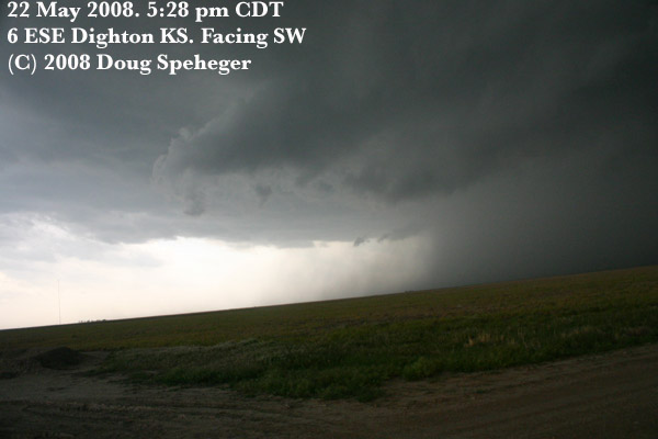
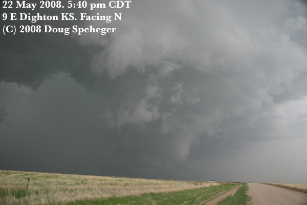
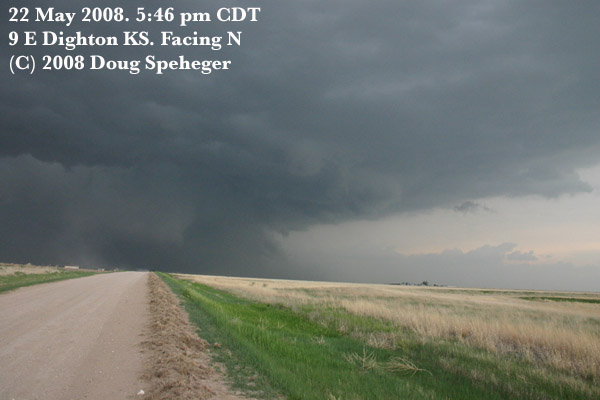
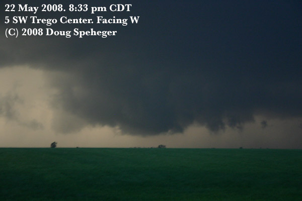
Thursday, May 22 - DIGHTON KS
569 miles, 12 hours. Supercell with weak tornado
| 
Chase Vacation: Day 1 actually out in the field. We left Norman with a target of an area west of Great Bend KS near a dryline that was to set up in western Kansas. It was an early start to the storms with large tornadoes occurring northeast of Denver even before we got to Wichita. The storms on the dryline developed earlier than expected as well. We were heading west from Great Bend when an initial storm was developing near Garden City and moving north. It was passing to the north by the time we were nearing Dighton KS. Meanwhile another storm had developed to the south, so we targeted that storm near Dighton. We initially were going to drive south from Dighton, but the storm core was approaching the highway, so we moved east in front of it. Southeast of Dighton we watched some cloud-base rotation despite a relatively unorganized base move toward us. But then quickly, the base organized somewhat, a funnel cloud developed, and a dust bowl developed a mile or two to our south in association with the small funnel cloud indicated a tornado. But we did not get any pictures since we decided we needed to get back north to the highway and then move east. We thought this was going to be the start of something more significant, but it never developed beyond the small funnel and dust bowl stage which only lasted a minute or so. Although cloud-base rotation and perhaps a funnel continued with the storm as it moved north. Another possible funnel cloud developed as well as some blowing dust (seen just west of the road on the photo), but no discernible rotation was noted with the blowing dust. We followed the storm north, but did not see much more with it. And ended up on some roads that were very muddy and messy when we got north of Collyer KS, so we gave up following it. We got up to WaKeeney and ran into my friend Dave Dowell. While chatting with him, a new storm developed southwest of WaKeeney, so we went south to look at it. We had a nice view of the base (or zoomed in view of the base) for a while, with a well developed rear-flank downdraft clear slot (photo on right), but the RFD filled with rain as another shower moved into this storm. This hid the area of interest from our view. Dave saw a small, low-contrast tornado from farther north that was obscured from us by the rain, but we did miss getting the hail core... at least with this storm. This weak tornado actually struck a portion of WaKeeney. We slowly crept north back to WaKeeney to avoid the hail, but another storm formed to its south and gave us some nickel to quarter size hail while trying to find lodging in WaKeeney. We ended up going east and staying in Hays for the night. |
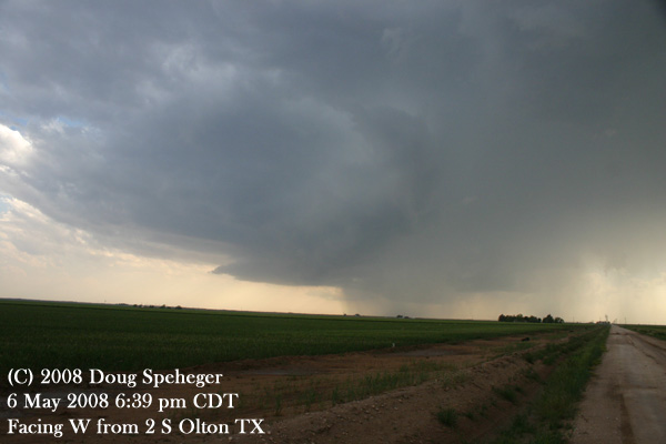
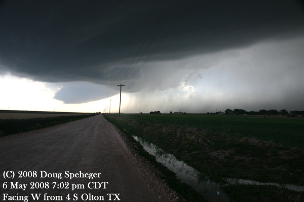
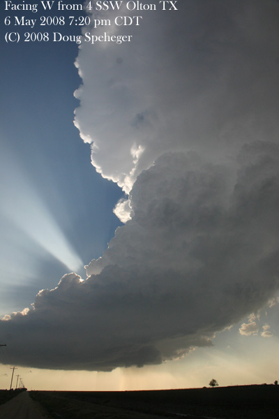
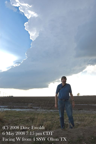
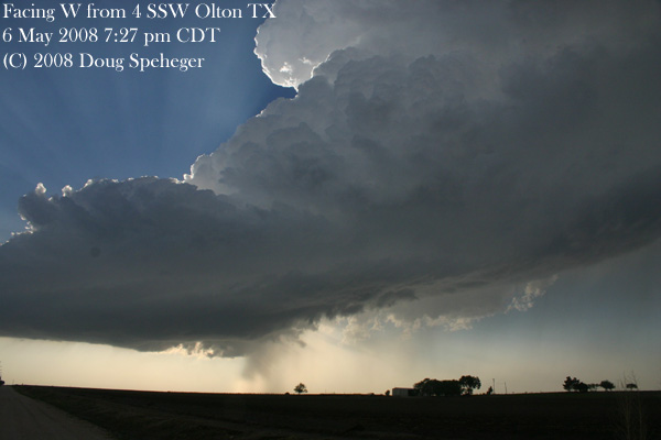
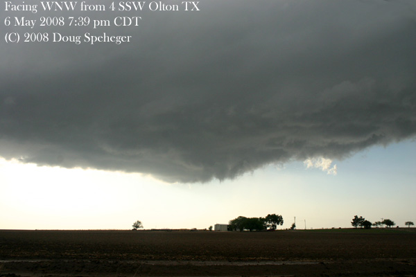
Tuesday, May 6 - OLTON TX
828 miles, 16.75 hours. Multiple supercells
|
Dave took three time-lapse segments, and made this video clip: http://www.okweatherwatch.com/2008/050608.wmv. |
 Dave and I drove to Amarillo, then waited for storms to develop. In a scene reminiscent of "Twister", we
even took the opportunity to visit Dave's aunt near Amarillo. We drove west to Vega watching some towers
developing. They were persistently trying to develop, but never could take hold. Meanwhile, we saw on
radar a storm developing to our southwest in an area northeast of Lubbock, so we went down to play it.
The overall storm seemed
Dave and I drove to Amarillo, then waited for storms to develop. In a scene reminiscent of "Twister", we
even took the opportunity to visit Dave's aunt near Amarillo. We drove west to Vega watching some towers
developing. They were persistently trying to develop, but never could take hold. Meanwhile, we saw on
radar a storm developing to our southwest in an area northeast of Lubbock, so we went down to play it.
The overall storm seemed
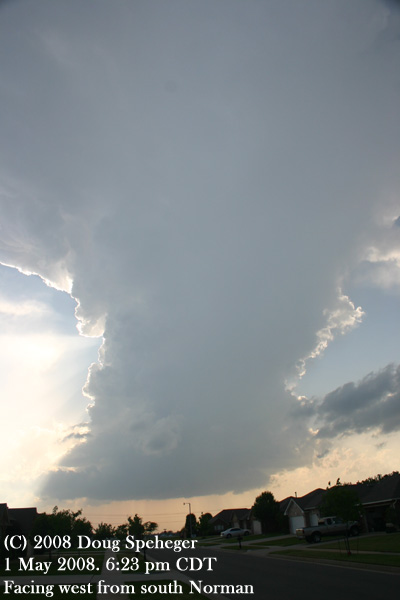
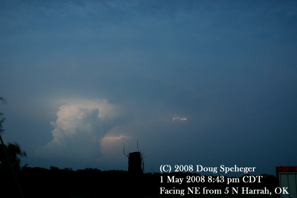
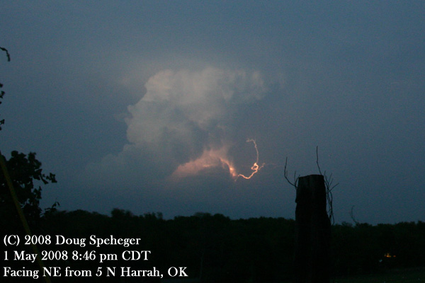
Thursday, May 1 - OKC/Harrah
103 miles, 4 hours. Supercell
|
|
 I was not convinced storms would form nearby (probably still somewhat a reaction from last Thursday's bust), but
there was enough chance that I kept my gear handy. While at Erin's, a
I was not convinced storms would form nearby (probably still somewhat a reaction from last Thursday's bust), but
there was enough chance that I kept my gear handy. While at Erin's, a
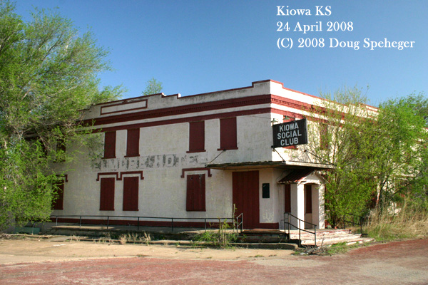
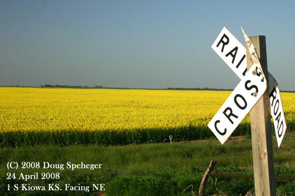
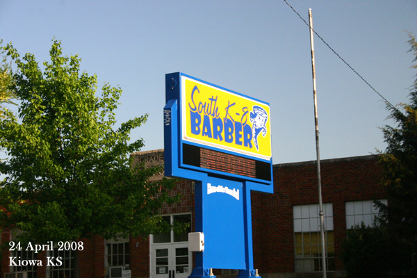
Thursday, April 24 - KIOWA KS
366 miles, 9 hours. Nothing. Absolutely nothing
|
|
 (a.k.a. the Canola Chase, or Dormant Weather.)
Well, it was one of those days where if storms develop, they will be severe and potentially
tornadic. But first you need a storm. And to get a storm, first you need a cloud. And
despite some towering cumulus seen on satellite in western Barber County Kansas, by the time
we drove to Barber County, the clouds were gone leaving the area with perfectly clear skies
without even a hint of cloud filaments (well, except for a contrail). So we arrived at Kiowa,
found the
(a.k.a. the Canola Chase, or Dormant Weather.)
Well, it was one of those days where if storms develop, they will be severe and potentially
tornadic. But first you need a storm. And to get a storm, first you need a cloud. And
despite some towering cumulus seen on satellite in western Barber County Kansas, by the time
we drove to Barber County, the clouds were gone leaving the area with perfectly clear skies
without even a hint of cloud filaments (well, except for a contrail). So we arrived at Kiowa,
found the
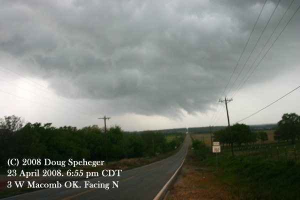
Wednesday April 23 - LEXINGTON
89 miles, 3.75 hours. Supercell
|
|
 A storm developed a bit south of Norman that seemed to have some interesting structure and
possibly some circulation per what we saw on some local media coverage. And it was close,
so we went south to Lexington to check it out. We ended up behind a slow-moving farm
implement on the highway, which caused a bit of concern when we found the updraft just to
the southwest. But we were able to get safely south of the storm. Looking north from
Lexington, the storm had some very good structure (see the photo on the right). But it
was short-lived as there was some sort of storm evolution that disorganized it. We followed
it to Etowah,
A storm developed a bit south of Norman that seemed to have some interesting structure and
possibly some circulation per what we saw on some local media coverage. And it was close,
so we went south to Lexington to check it out. We ended up behind a slow-moving farm
implement on the highway, which caused a bit of concern when we found the updraft just to
the southwest. But we were able to get safely south of the storm. Looking north from
Lexington, the storm had some very good structure (see the photo on the right). But it
was short-lived as there was some sort of storm evolution that disorganized it. We followed
it to Etowah,
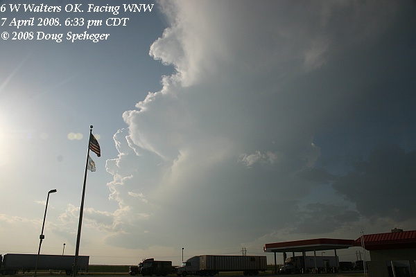
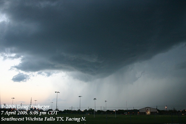
Monday, April 7 - WICHITA FALLS TX/Okarche OK
401 miles, 10.5 hours. 2 Supercells
|
|
 We got a late start and a storm had already developed in Wilbarger County Texas as we were leaving Okarche. It produced at
least one tornado while we were still north of Lawton. We had initial thoughts of playing this storm as it moves east-northeast
into Oklahoma, but it turned to the right and moved east-southeast toward Wichita Falls and we did not see a good way to get in
position, so we hung out at the Walters service area to wait for other storms to develop. While waiting there, the storm to our
south
We got a late start and a storm had already developed in Wilbarger County Texas as we were leaving Okarche. It produced at
least one tornado while we were still north of Lawton. We had initial thoughts of playing this storm as it moves east-northeast
into Oklahoma, but it turned to the right and moved east-southeast toward Wichita Falls and we did not see a good way to get in
position, so we hung out at the Walters service area to wait for other storms to develop. While waiting there, the storm to our
south
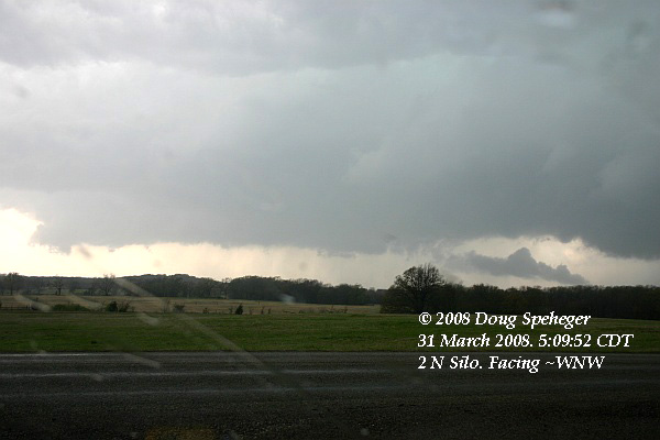
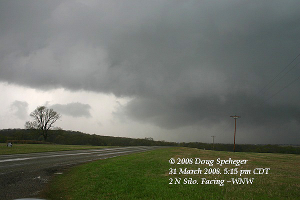
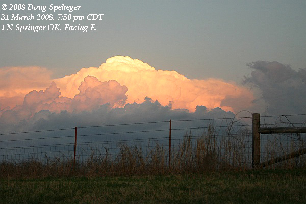
Monday, March 31 - SILO/ Kenefic
349 miles. 7.25 hours. Three storms. Two supercells, one with good structure
|
|
 We went east from Norman with the idea of dropping south and finding one of a few storms to play. Winds have veered in southwestern
Oklahoma to the I-35 corridor, so we wanted to be in southeast Oklahoma. We even had a storm increase over us in east Norman and
drop small hail on us. We dropped south in Hughes County and watched two storms, one in southern Hughes County and one near Clarita.
Neither storm was too organized. So we continued south to a more promising storm near Lake Texoma, and had a tornado warning issued
on it. We soon got a view driving west from near Cobb, then continued west to Brown then south on Silo Road to watch the better
organized storm (see right and
We went east from Norman with the idea of dropping south and finding one of a few storms to play. Winds have veered in southwestern
Oklahoma to the I-35 corridor, so we wanted to be in southeast Oklahoma. We even had a storm increase over us in east Norman and
drop small hail on us. We dropped south in Hughes County and watched two storms, one in southern Hughes County and one near Clarita.
Neither storm was too organized. So we continued south to a more promising storm near Lake Texoma, and had a tornado warning issued
on it. We soon got a view driving west from near Cobb, then continued west to Brown then south on Silo Road to watch the better
organized storm (see right and 